As of today, four years have passed since the last time I posted here. Wow. Perhaps evident by the subject matter of the post that has had the distinction of being labeled the most recent for 48 months in a row, I never really intended to stop posting here like I did. Nevertheless, in retrospect, several circumstances at the time led to that very thing happening. With that being the case, I wonder if, say, I start routinely posting here again, whether I could still place the phrase "since 2001" on any logo displayed at the top of the page?
I bring that up because I’m seriously considering once again writing every so often on here. To be honest, I’m not so sure what I would discuss with any regularity, but, then again, I remember that being an occasional problem in the past but not one that could be overcome. In any event, I do have to say that I have sometimes missed the long-form style of writing that works well with this format.
One thing I could use my blog for could be to provide a background to any new photos I include on my Flickr page, which now has over 2,000 images and is largely where I’ve concentrated my attention in the four years since my last post (www.mitchsblog.com redirects there now too). Actually, thinking this over, that would be hardly revolutionary, since I remember that sharing recent photos I had taken as well as discussing the details of how they came about made up a significant portion of my posts in the past.
Taking into account the last thing I posted in 2008, I also obviously enjoyed writing about the weather, specifically in Brainerd, Minnesota. Being my hometown, that I picked that locale to talk about was no coincidence, but there was another good reason too. I believe I wrote about this sometime in the past, but, not having refreshed my memory by combing through previous blog posts, I don’t know for sure. Anyhow, I spent a good amount of time collecting all of the weather records there are to collect with regard to the city of Brainerd and sorted all that information into easily read tables and charts such as the ones available for St. Cloud, Minnesota on this website. With information like this, comparisons between days, months, years, or any other period can be made with ease and may even be enjoyable to anybody who has an interest in weather.
I once had all of this information online, but I never found a new hosting service when Yahoo! shut down Geocities. Nonetheless, all of the files that made up the website are still on my computer, and after updating with data for the most recent years as well as improving some formatting issues, I would like to make the tables and charts once again available and linked to at the website showing the data my personal weather station in Brainerd have been supplying to Weather Underground since the end of 2006. Assuming I re-launch the website containing weather statistics, I would also like to perhaps provide monthly weather summaries chronicling the month that has just passed. Preliminarily speaking, I’m thinking I could use the blog as a way to share and archive these summaries.
Anyway, all of what I’ve written, which actually is much more than I was ever intending to write, is to say that this blog may get revived sometime in the future. If you’re reading this now, I guess you might just want to stay tuned to see what happens.
Yesterday at 48 minutes past midnight, CDT, for the first time in six months, the sun aligned itself with the equator. This marked, of course, the vernal equinox and the end of winter in the northern hemisphere. Even so, meteorological winter, the winter that meteorologists use to reckon average winter temperatures, precipitation, and other variables, came to a close on the first of March after beginning on the first of December.
So the three months that cover meteorological winter were exceptionally cold this year in the Upper Midwest, weren’t they? Well, yes, perhaps, when you view them in terms of a decadal perspective, but, no, not really, when you compare them against all winters of the past century.
The reason for this is that the winter of 2007-08, while colder than average in the Upper Midwest, wasn’t really that cold compared to how cold many winters in the past have been. Instead, it most likely felt unusually cold this past winter because the last time a winter had been so cold was seven years ago in 2000-01 and because the intervening six winters during that seven year gap were not only warmer than average, but, with only a couple of exceptions, much warmer than average.
Let’s concentrate on Minnesota a bit. The average 2007-08 winter temperature was 9.9°F, or 1.8°F below the 1896-2008 average. It was 38th coldest winter in Minnesota on record, which starts during the winter of 1895-96. The last winter that had a comparable average temperature was, like I mentioned, 2000-01, which had an average temperature of 8.8°F. February 2008, coming in at 3.3°F below the 1896-2008 average, had the largest departure from average (December and January were 2.1°F below average and 0.6°F above average, respectively).
Going to Brainerd now, the preliminary average winter 2007-08 temperature was 10.3°F. I must use the word preliminary because that is the average temperature from the automated observation station at the Brainerd Lakes Regional Airport. For my Climate of Brainerd website, all (recent) data come from the cooperative weather observer station operated by Brainerd Public Utilities near the Mississippi River on the north end of town. Unfortunately, unlike the automated station at the airport, data from this station are not made public until a few months after they’re recorded. As a result, I must use data from the airport right now to determine the average winter temperature.
The difference between what’s recorded at the airport what what’s recorded near the river isn’t usually that large, so some comparisons can still be made with the airport’s measurements in hand.
10.3°F is about 1°F below the 1898-2007 average winter temperature and, as you’ve heard before, would make it the coldest average since the winter of 2000-01. December 2007 at the airport was colder than average, January 2008 was right near average, and February 2008 was colder than average. Interestingly, the coldest temperature recorded at the airport during winter was only -24°F on January 24, February 19, and February 21. On average, Brainerd records 3 or 4 temperatures of -30°F or lower during winter, and actually, if the coldest that the cooperative station got during winter also ends up being -24°F, that would be the sixth warmest “lowest temperature recorded during the winter” on record. This little tidbit leads credence to the thought that what dragged this past winter down temperature-wise were not the daily minimum temperatures seen during the outbreaks of arctic air, but the below-average daily maximum temperatures associated with the cold air intrusions.
I have the space, but unfortunately not the time, to discuss precipitation patterns during the past winter. With that in mind, let me just say that winter was much drier than average in Minnesota and North Dakota but much wetter than average in the rest of the Upper Midwest. Still, thanks to two significant snowstorms during the first week of December that blanketed the region with roughly 8 to 15 inches of snow, most of central and northern Minnesota and eastern North Dakota maintained an extensive snow pack throughout the winter months for the first time in years. If you enjoyed the colder temperatures of this past winter, you should be exceptionally thankful for the timing and precipitation that fell from these early-December storms. If these storms had not provided the snow that they did when they did, it’s doubtful that winter temperatures would have been as cold as they were. A basic concept discussed in meteorology classes (and one that I was tested on just last week in ATSC 310 – Introduction to Weather Forecasting) is that of how a deep snow pack can affect temperatures. Snow, being white, not only does an efficient job of reradiating solar radiation into space, but also emits infrared energy and acts as an insulator that prevents heat stored in soil from reaching the air. This, coupled with the fact that it takes energy to either melt or sublimate snow, means that unless some other factor is at play, an area with a good snow cover will by and large be colder than one with little or no snow cover. Furthermore, the newer the snow is, the better it is at preventing temperatures from warming too much. The temperature differences between a snow covered area and an area with no snow cover that are both being impacted by the same air mass can sometimes be dramatic – the snow covered area could be at 28°F while the area with just bare ground could be reading 48°F. One of the first things to look at if you want cold temperatures is how much snow is on the ground and how new it is.
What was the most likely culprit in making the winter of 2007-08 turn out as it did? La Niña. Not since the winter of 2000-01 (hey, haven’t I mentioned these two years before?) has La Niña been as strong. Although it’s the weak La Niñas that seem to have a stronger tendency to bring colder than average temperatures to the Upper Midwest, almost all winters in the region influenced by La Niña have featured average to colder than average temperatures. Precipitation patterns during a La Niña are more variable, however. It’ll be interesting to see how La Niña, which remains quite strong, affects the weather pattern during the rest of March, April, and perhaps even May. There is a pretty good correlation between a strong La Niña event and a colder than average spring in the Upper Midwest.
Now to some pictures – first are a few figures related to the weather discussion of this post and second are some of my favorite pictures taken here at UND during the past winter. Real quickly, let me just say that Grand Forks also had a cold, dry winter. The average temperature was 4.9°F, which is coincidently 4.9°F below the 30-year normal. The coldest temperature was -33°F on February 20; this temperature also set a new daily record low at Grand Forks International Airport. Click here to view The Weather Channel’s local forecast from that morning.
Bar graph showing average winter temperatures in Minnesota since the winter of 1895-96 (from the National Climactic Data Center's Minnesota climate summaries)
As is usual, Minnesota's average winter temperature was the coldest among the lower 48 states; North Dakota's was the second coldest, which is also common (from the National Climactic Data Center's U.S. Climate at a Glance)
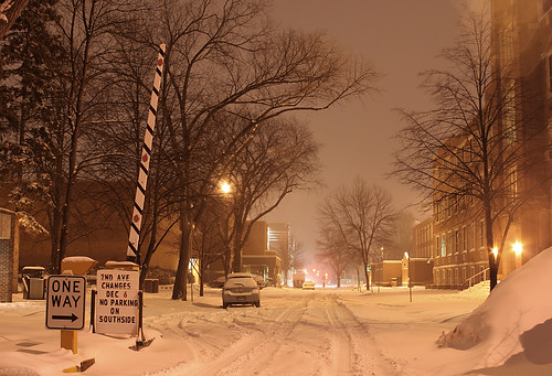
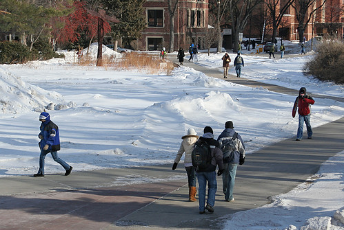
Second Avenue North on a snowy December evening at the University of North Dakota in Grand Forks
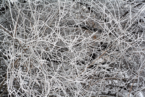
Thick hoarfrost covered all vegetation outdoors on a pleasant January afternoon in Grand Forks, North Dakota
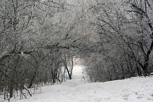
Trees covered in thick hoarfrost make walking along this path in Grand Forks, North Dakota especially wonderful on a January afternoon
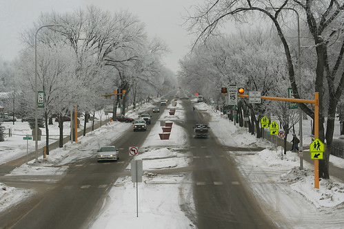
Trees covered in thick hoarfrost line University Avenue at the University of North Dakota in Grand Forks on a nice January morning.
This was one of those days at the University of North Dakota in Grand Forks where bundling up from head to toe was an absolute necessity. When this photo was taken, the temperature was -14°F and the wind was blowing from the northwest at 27 mph, producing a wind chill of -44°F.
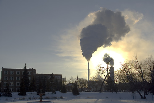
At a temperature of -32°F (-36°C), water vapor tends to stay in the atmosphere for a while. Such was the case around the UND heating plant about an hour after sunrise. What isn't immediately evident in this picture, taken on the coldest morning of the 2007-08 winter, was that the wind chill was an incredible -54°F (-48°C).
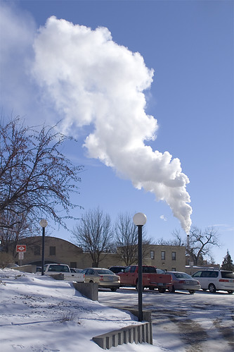
A ominous cloud of steam rises above the UND heating plant amid an ambient temperature of -19°F (-28°C) on one of the coldest days of the 2007-08 winter.
Here's a tradition I'll hold on to. Although I can't say it's the 7th consecutive year that I've posted a list of what I believe to be the top 10 commercials shown during the Super Bowl (I skipped out on doing this in 2005 for some reason), this is the 7th year that I've put together a list.
Hopefully you're able to play all of the commercials. Otherwise, if you caught the Super Bowl, you'll just have play the commercial from memory.
Today is the sixth birthday of my blog. For your enjoyment, I’ve posted two appropriate pictures. One depicts a Hot Wheels® themed cake and the other is a coloring page, courtesy of "Lil’ Fingers," that you can print off and fill in with whatever color(s) you want. I’d recommend using some yellow.
Something I hope to accomplish during my current break from school is to get my Flickr photo page populated with pictures I’ve taken over the last two years or so. That’s right, I’m now placing my photos on Flickr. Thanks to Yahoo taking the site over and merging it into its family of services, getting an account set up there back in October was quick and easy. There were some problems that I saw with Flickr about a year or so ago when I was looking around for a good place to store and share my photos online, but, for the most part, they all seem to have subsided when I took another look at the site in October, so that's why I decided to host my photos there.
As I type this, I have a little over 100 photos on Flickr, but only two "sets" – one from my trip to see the Canadian Pacific Railway's Holiday Train last week in west-central Minnesota and another from an extensive mini-vacation in northeastern North Dakota in October. Hopefully, within the next week or two, I will have placed a couple hundred more photos into my account. I don’t believe any of the photos will be “new,” or ones that I haven’t yet shared here on the blog, but I just thought I’d let you know the address of the website (http://www.flickr.com/photos/mwahlsten) where you’ll be able to view all of my photos in the foreseeable future.
I suppose it’s time for an extremely overdue update. I was actually thinking of taking the blog down, partly due to diminishing interest, but I’ve decided to leave it up – for now. Its sixth birthday is approaching, and it does make me proud to know that I’ve been regularly (depending on your definition of the word, of course) contributing for that long of a time period. Most people hadn’t even heard of the word blog when I began this in 2001; look how far society has evolved since then!
Really, not much has happened in my life since the last time I wrote anything of significance. I started my third year at UND in the middle of August and have been kept consistently busy with classes and assignments since then, even though my schedule is not necessarily that crowded. My major (chemistry) and minors (German and atmospheric sciences) remain the same as last year. As long as some possible scheduling conflicts work themselves out, I should be able to enroll in German 408 (Second Semester German IV) this upcoming spring semester. This is the final course I need to fulfill requirements for a minor in German, so hopefully I’ll be able to take it and officially say that I have a minor in German upon the successful completion of the course’s final on May 7, 2008.
If you’ve tried accessing the blog through mitchsblog.com recently, you will have noticed that it’s not working. I’m not quite sure what the problem is, but it likely has something to do with my domain name registrar. The solution to the problem may involve spending some money. Nevertheless, I’m going to try my best to get it fixed.
Finally, I wanted to say something about gloomy news that came out of Brainerd last week when area voters handily rejected a school district levy referendum. As a result, the district will now have to make $5.5 million worth of budget cuts for the next school year. These cuts will be comprehensive and deep, affecting students at every grade level and at every school in the district. Some of the proposals include laying off between 60-100 teachers, eliminating a huge variety of academic and athletic programs, and closing two elementary schools (to my sorrow, one of the two closed will likely be Lincoln, the one I attended). It greatly disappoints me to think of all that will be lost when the 2008-09 school year begins next September. However, even with that said, and despite the fact that I sent in a supportive absentee ballot, I can see to a certain degree why more voters of the Brainerd School District disapproved of the referendum than approved. Although the reasons for the failed referendum in Brainerd likely cannot be transposed to explain the results in other cities that held levy referendums, it should be noted that of the 99 school districts in Minnesota that had a referendum on the ballot, a majority – 67 – got their referendums passed either completely (61 districts) or partially (6 districts asked more than one question as part of their referendum). 32 districts saw complete failure, including Brainerd, Crosby-Ironton, Wadena-Deer Creek, Milaca, and Princeton.
The full results of all referendums asked in 2007 across the state can be found by clicking here and accessing a PDF put together by the Minnesota School Boards Association. Note that only five districts (Frazee-Vergas, Granada-Huntley-East Chain, Jackson County Central, Norman County East, and Windom) asked for a larger per-pupil increase in tax revenue funding than Brainerd. The referendums in all five of these districts passed.
Day 10 Summary Hallock, Minnesota to Brainerd, Minnesota
The final day of my 2007 vacation began in Hallock, in Minnesota's far northwestern corner. Although the city only has 1,196 residents, it nevertheless is one of the most important cities in its locale in Minnesota. One of the reasons for this is undoubtedly because it is the county seat of Kittson County.
I don’t know what it is, but I really like the northwestern corner of Minnesota. It’s a unique part of the state due to its connectedness with Canada. Ecologically speaking, the region is also quite unique, since it lies within Minnesota’s only example of a tallgrass aspen parklands system. As such, the scenery can be described as being a transition zone between tallgrass prairie and aspen forest. There really is no other place in Minnesota that looks exactly the same.
Kittson County is one of the only counties in Minnesota that has no natural lakes. The sole lake in the county, Lake Bronson, was created in the 1930s when a dam was built along South Branch of the Two Rivers.
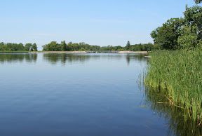
As it turned out, Lake Bronson was one of the tourist attractions I saw in the region. The lake, and the mixed tallgrass prairie/aspen forest landscape that surrounds it, are on display at the beautiful Lake Bronson State Park. All in all, I think I ended up spending a good couple of hours wandering around the park. Not only is there good scenery to see, but also some historic buildings that date back to the park’s construction by WPA and CCC crews during the Great Depression.
The trek back home to Brainerd started in earnest once I left the park. Although there are many ways to get to Brainerd from the city of Lake Bronson – adjacent to the park – I chose the one that would bring me through Grand Forks. I wanted to check out the city to ensure, I suppose you could say, that everything still appeared the same as when I left in May. For the most part, it did.
As the drive from the park to Grand Forks and Grand Forks to Brainerd was largely uneventful, and covered no territory that I haven’t already more or less thoroughly covered on here, I’ll just keep things short and say I made it home sometime around 7 in the evening. And with that, my superb 2007 vacation came to an end.
Pictures:
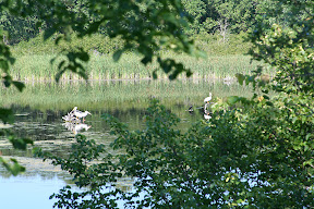
The first fourteen pictures were taken in Lake Bronson State Park These three pelicans were looking for lunch in the lake
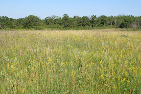
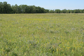
An example of tallgrasss prairie within the park
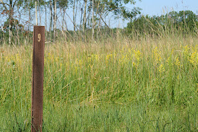
at trail marker #9 along the park's interpretive trail
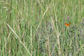
There were a lot of butterflies flying around in the prairie
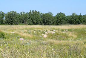
This depression was caused by a soil mining operation that was once located here
Another example of tallgrass paririe
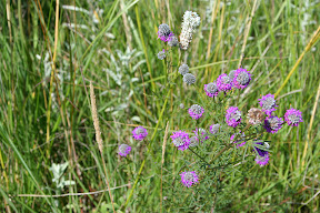
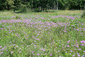
There were a lot of these purple flowers within the prairie - I don't know what these are called, but I believe they are an invasive species
So purple!
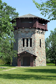
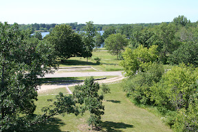
The water tower/observation tower
The view looking south from the tower
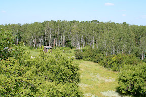
The view looking north from the tower - here's an example of an aspen forest within the park
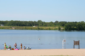
Even on a Tuesday morning, there were people enjoying the beach along Lake Bronson
Day 9 Summary Brandon, Manitoba to Hallock, Minnesota
Brandon's tourism slogan, “you belong in Brandon,” closely matched my feelings regarding the southwestern Manitoba city. In general, I found the city inhabited by 41,511 to be an exceptionally nice place to visit. It wasn’t that there were an abundance of tourist attractions, rather, it was just one of those cities that gave me good feelings.
One of the reasons for that might have been due to all the similarities I saw between Brandon and Grand Forks. Both cities are roughly the same size, both are situated in fertile river valleys, and both are significant centers of commerce and industry within their respective regions. Both cities actually have public universities within their boundaries as well, though Brandon University is quite a bit smaller than the University of North Dakota.
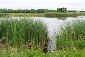
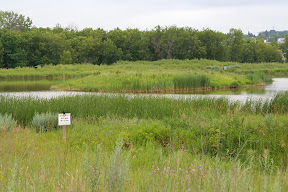
Besides stopping in at Safeway to get some exotic varities of potato chips, one of the chief places I visited in Brandon was the Riverbank Discovery Centre and adjacent hiking trails. The center provided some tourist information for the city of Brandon, while the trails wound around the Assinboine River and neighboring wetlands. There were even informative interpretive signs around a good portion of the trail network going through the wetlands.
At slightly past noon, I had to leave Brandon. I exited town heading east on the Trans-Can, which took me through some of the most agriculturally-developed land in Canada. Field after field of various crops could be seen alongside the road as it continued pressing deeper into the fertile, flat Red River Valley.
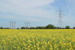
One of the more scenic sights along the way were the fields of canola. Though I had seen them since southwestern Saskatchewan, they seemed to become much more numerous as I traveled through southern Manitoba. These fields’ distinctive appearance made the landscape appear as if somebody took an airbrush and lightly painted it a school-bus yellow. It was quite striking, actually.
The biggest city in the 133 miles between Brandon and Winnipeg is Portage la Prairie (known locally as just "Portage"). This city of 12,748 is one of the leading centers of strawberry and potato production in North America. In fact, the J.R. Simplot Company opened an enormous potato processing plant there in 2003 to produce French fries for customers throughout Canada and the United States.
Portage la Prairie is also one of the most significant railroad centers in Canada, since it is situated along both the Canadian Pacific and Canadian National lines that run, more or less, across the country. Dozens of trains pass through Portage la Prairie on any given day.
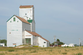
Since I had already visited Winnipeg for a few days last October, I decided to detour around the city to get to the border. The first detour was Manitoba Highway 13 south from Newton to Roland, followed by Manitoba Highway 23 east from Roland to Morris. The scenery along these roads wasn’t anything spectacular, but I did get to see some more of those old grain elevators that I enjoy.
From Morris, it’s a quick 25 mile drive on Manitoba Highway 75 to the border and the Emerson, MB/Pembina, ND crossing. As was the case 4 days earlier in Montana, I made it across the border with little incident.
After taking a quick look around the historic city of Pembina, it was time to get on the road – predominantly U.S. Highway 75 – and travel 21 miles south to Hallock, one of the largest cities in extreme northwestern Minnesota.
Pictures:
These purple flowers were all over the wetlands next to the Assiniboine River in Brandon
There were also hundreds of these frogs in the wetlands
The Assiniboine River
Another view of the Assiniboine River
Feeding geese near the river
This "fuzzy" grass was growing in many places throughout the wetlands
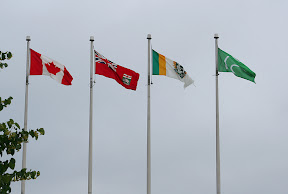
(from left to right) The flag of Canada, Manitoba, city of Brandon, Ducks Unlimited Canada
A canola field near Portage la Prairie
The grain elevator near Kane
The grain elevator near Lowe Farm (or "Lowe F rm")
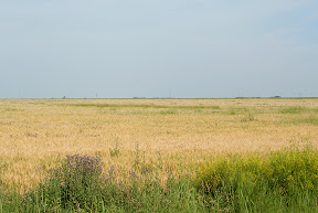
Red River Valley scenery near Morris
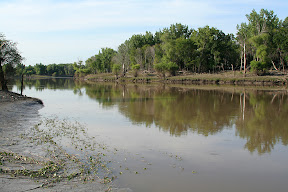
The Red River near Pembina - that's Minnesota on the other side; the Canadian border is about 2 miles up ahead
Click here to subscribe to Mitch's Blog through RSS!
Mitch's Blog Copyright 2001-2012 Mitch Wahlsten -- All Rights Reserved
The thoughts and opinions expressed are those of Mitch Wahlsten and the participants
Mitch's Blog began on December 23, 2001