
2007 Vacation: Day 9 Summary
Day 9 Summary
Brandon, Manitoba to Hallock, Minnesota
Brandon's tourism slogan, “you belong in Brandon,” closely matched my feelings regarding the southwestern Manitoba city. In general, I found the city inhabited by 41,511 to be an exceptionally nice place to visit. It wasn’t that there were an abundance of tourist attractions, rather, it was just one of those cities that gave me good feelings.
One of the reasons for that might have been due to all the similarities I saw between Brandon and Grand Forks. Both cities are roughly the same size, both are situated in fertile river valleys, and both are significant centers of commerce and industry within their respective regions. Both cities actually have public universities within their boundaries as well, though Brandon University is quite a bit smaller than the University of North Dakota.
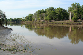
Besides stopping in at Safeway to get some exotic varities of potato chips, one of the chief places I visited in Brandon was the Riverbank Discovery Centre and adjacent hiking trails. The center provided some tourist information for the city of Brandon, while the trails wound around the Assinboine River and neighboring wetlands. There were even informative interpretive signs around a good portion of the trail network going through the wetlands.
At slightly past noon, I had to leave Brandon. I exited town heading east on the Trans-Can, which took me through some of the most agriculturally-developed land in Canada. Field after field of various crops could be seen alongside the road as it continued pressing deeper into the fertile, flat Red River Valley.
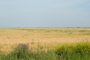
One of the more scenic sights along the way were the fields of canola. Though I had seen them since southwestern Saskatchewan, they seemed to become much more numerous as I traveled through southern Manitoba. These fields’ distinctive appearance made the landscape appear as if somebody took an airbrush and lightly painted it a school-bus yellow. It was quite striking, actually.
The biggest city in the 133 miles between Brandon and Winnipeg is Portage la Prairie (known locally as just "Portage"). This city of 12,748 is one of the leading centers of strawberry and potato production in North America. In fact, the J.R. Simplot Company opened an enormous potato processing plant there in 2003 to produce French fries for customers throughout Canada and the United States.
Portage la Prairie is also one of the most significant railroad centers in Canada, since it is situated along both the Canadian Pacific and Canadian National lines that run, more or less, across the country. Dozens of trains pass through Portage la Prairie on any given day.
Since I had already visited Winnipeg for a few days last October, I decided to detour around the city to get to the border. The first detour was Manitoba Highway 13 south from Newton to Roland, followed by Manitoba Highway 23 east from Roland to Morris. The scenery along these roads wasn’t anything spectacular, but I did get to see some more of those old grain elevators that I enjoy.
From Morris, it’s a quick 25 mile drive on Manitoba Highway 75 to the border and the Emerson, MB/Pembina, ND crossing. As was the case 4 days earlier in Montana, I made it across the border with little incident.
After taking a quick look around the historic city of Pembina, it was time to get on the road – predominantly U.S. Highway 75 – and travel 21 miles south to Hallock, one of the largest cities in extreme northwestern Minnesota.
Pictures:

These purple flowers were all over the wetlands next to the Assiniboine River in Brandon

There were also hundreds of these frogs in the wetlands
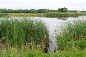
The Assiniboine River
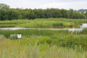
Another view of the Assiniboine River

Feeding geese near the river

This "fuzzy" grass was growing in many places throughout the wetlands
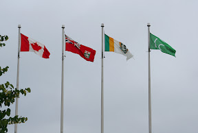
(from left to right) The flag of Canada, Manitoba, city of Brandon, Ducks Unlimited Canada
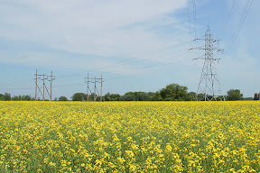
A canola field near Portage la Prairie

The grain elevator near Kane
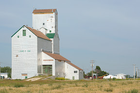
The grain elevator near Lowe Farm (or "Lowe F rm")
Red River Valley scenery near Morris
The Red River near Pembina - that's Minnesota on the other side; the Canadian border is about 2 miles up ahead
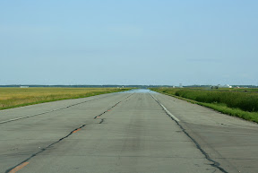
Scenery near Hallock along U.S. Highway 75
Videos:
No videos related to day 9
These purple flowers were all over the wetlands next to the Assiniboine River in Brandon
There were also hundreds of these frogs in the wetlands
The Assiniboine River
Another view of the Assiniboine River
Feeding geese near the river
This "fuzzy" grass was growing in many places throughout the wetlands
(from left to right) The flag of Canada, Manitoba, city of Brandon, Ducks Unlimited Canada
A canola field near Portage la Prairie
The grain elevator near Kane
The grain elevator near Lowe Farm (or "Lowe F rm")
Red River Valley scenery near Morris
The Red River near Pembina - that's Minnesota on the other side; the Canadian border is about 2 miles up ahead
Scenery near Hallock along U.S. Highway 75
Videos:
No videos related to day 9
Labels: 2007 Vacation, Pictures
posted by Mitch Wahlsten at 1:31 PM
0 comments
![]()


0 Comments:
Post a Comment
<< Home