
Winter of 2007-08 Musings
Yesterday at 48 minutes past midnight, CDT, for the first time in six months, the sun aligned itself with the equator. This marked, of course, the vernal equinox and the end of winter in the northern hemisphere. Even so, meteorological winter, the winter that meteorologists use to reckon average winter temperatures, precipitation, and other variables, came to a close on the first of March after beginning on the first of December.
So the three months that cover meteorological winter were exceptionally cold this year in the Upper Midwest, weren’t they? Well, yes, perhaps, when you view them in terms of a decadal perspective, but, no, not really, when you compare them against all winters of the past century.
The reason for this is that the winter of 2007-08, while colder than average in the Upper Midwest, wasn’t really that cold compared to how cold many winters in the past have been. Instead, it most likely felt unusually cold this past winter because the last time a winter had been so cold was seven years ago in 2000-01 and because the intervening six winters during that seven year gap were not only warmer than average, but, with only a couple of exceptions, much warmer than average.
Let’s concentrate on Minnesota a bit. The average 2007-08 winter temperature was 9.9°F, or 1.8°F below the 1896-2008 average. It was 38th coldest winter in Minnesota on record, which starts during the winter of 1895-96. The last winter that had a comparable average temperature was, like I mentioned, 2000-01, which had an average temperature of 8.8°F. February 2008, coming in at 3.3°F below the 1896-2008 average, had the largest departure from average (December and January were 2.1°F below average and 0.6°F above average, respectively).
Going to Brainerd now, the preliminary average winter 2007-08 temperature was 10.3°F. I must use the word preliminary because that is the average temperature from the automated observation station at the Brainerd Lakes Regional Airport. For my Climate of Brainerd website, all (recent) data come from the cooperative weather observer station operated by Brainerd Public Utilities near the Mississippi River on the north end of town. Unfortunately, unlike the automated station at the airport, data from this station are not made public until a few months after they’re recorded. As a result, I must use data from the airport right now to determine the average winter temperature.
The difference between what’s recorded at the airport what what’s recorded near the river isn’t usually that large, so some comparisons can still be made with the airport’s measurements in hand.
10.3°F is about 1°F below the 1898-2007 average winter temperature and, as you’ve heard before, would make it the coldest average since the winter of 2000-01. December 2007 at the airport was colder than average, January 2008 was right near average, and February 2008 was colder than average. Interestingly, the coldest temperature recorded at the airport during winter was only -24°F on January 24, February 19, and February 21. On average, Brainerd records 3 or 4 temperatures of -30°F or lower during winter, and actually, if the coldest that the cooperative station got during winter also ends up being -24°F, that would be the sixth warmest “lowest temperature recorded during the winter” on record. This little tidbit leads credence to the thought that what dragged this past winter down temperature-wise were not the daily minimum temperatures seen during the outbreaks of arctic air, but the below-average daily maximum temperatures associated with the cold air intrusions.
I have the space, but unfortunately not the time, to discuss precipitation patterns during the past winter. With that in mind, let me just say that winter was much drier than average in Minnesota and North Dakota but much wetter than average in the rest of the Upper Midwest. Still, thanks to two significant snowstorms during the first week of December that blanketed the region with roughly 8 to 15 inches of snow, most of central and northern Minnesota and eastern North Dakota maintained an extensive snow pack throughout the winter months for the first time in years. If you enjoyed the colder temperatures of this past winter, you should be exceptionally thankful for the timing and precipitation that fell from these early-December storms. If these storms had not provided the snow that they did when they did, it’s doubtful that winter temperatures would have been as cold as they were. A basic concept discussed in meteorology classes (and one that I was tested on just last week in ATSC 310 – Introduction to Weather Forecasting) is that of how a deep snow pack can affect temperatures. Snow, being white, not only does an efficient job of reradiating solar radiation into space, but also emits infrared energy and acts as an insulator that prevents heat stored in soil from reaching the air. This, coupled with the fact that it takes energy to either melt or sublimate snow, means that unless some other factor is at play, an area with a good snow cover will by and large be colder than one with little or no snow cover. Furthermore, the newer the snow is, the better it is at preventing temperatures from warming too much. The temperature differences between a snow covered area and an area with no snow cover that are both being impacted by the same air mass can sometimes be dramatic – the snow covered area could be at 28°F while the area with just bare ground could be reading 48°F. One of the first things to look at if you want cold temperatures is how much snow is on the ground and how new it is.
What was the most likely culprit in making the winter of 2007-08 turn out as it did? La Niña. Not since the winter of 2000-01 (hey, haven’t I mentioned these two years before?) has La Niña been as strong. Although it’s the weak La Niñas that seem to have a stronger tendency to bring colder than average temperatures to the Upper Midwest, almost all winters in the region influenced by La Niña have featured average to colder than average temperatures. Precipitation patterns during a La Niña are more variable, however. It’ll be interesting to see how La Niña, which remains quite strong, affects the weather pattern during the rest of March, April, and perhaps even May. There is a pretty good correlation between a strong La Niña event and a colder than average spring in the Upper Midwest.
Now to some pictures – first are a few figures related to the weather discussion of this post and second are some of my favorite pictures taken here at UND during the past winter. Real quickly, let me just say that Grand Forks also had a cold, dry winter. The average temperature was 4.9°F, which is coincidently 4.9°F below the 30-year normal. The coldest temperature was -33°F on February 20; this temperature also set a new daily record low at Grand Forks International Airport. Click here to view The Weather Channel’s local forecast from that morning.
 Statewide average winter temperature ranks (from the National Climactic Data Center's 3-month National Climate Summary)
 Statewide average winter precipitation ranks (from the National Climactic Data Center's 3-month National Climate Summary)
 Bar graph showing average winter temperatures in Minnesota since the winter of 1895-96 (from the National Climactic Data Center's Minnesota climate summaries)
 As is usual, Minnesota's average winter temperature was the coldest among the lower 48 states; North Dakota's was the second coldest, which is also common (from the National Climactic Data Center's U.S. Climate at a Glance)
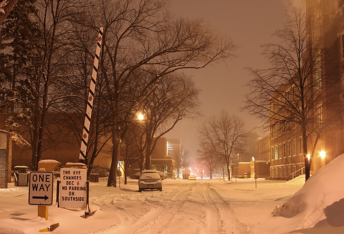
Second Avenue North on a snowy December evening at the University of North Dakota in Grand Forks
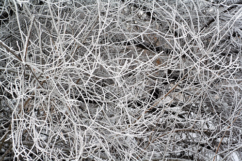
Thick hoarfrost covered all vegetation outdoors on a pleasant January afternoon in Grand Forks, North Dakota
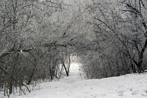
Trees covered in thick hoarfrost make walking along this path in Grand Forks, North Dakota especially wonderful on a January afternoon
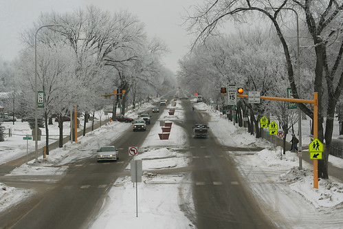
Trees covered in thick hoarfrost line University Avenue at the University of North Dakota in Grand Forks on a nice January morning.
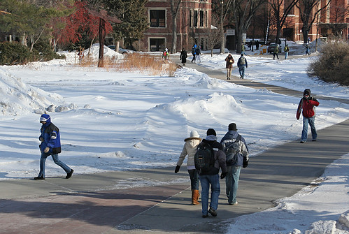
This was one of those days at the University of North Dakota in Grand Forks where bundling up from head to toe was an absolute necessity. When this photo was taken, the temperature was -14°F and the wind was blowing from the northwest at 27 mph, producing a wind chill of -44°F.
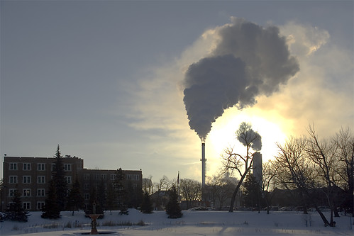
At a temperature of -32°F (-36°C), water vapor tends to stay in the atmosphere for a while. Such was the case around the UND heating plant about an hour after sunrise. What isn't immediately evident in this picture, taken on the coldest morning of the 2007-08 winter, was that the wind chill was an incredible -54°F (-48°C).
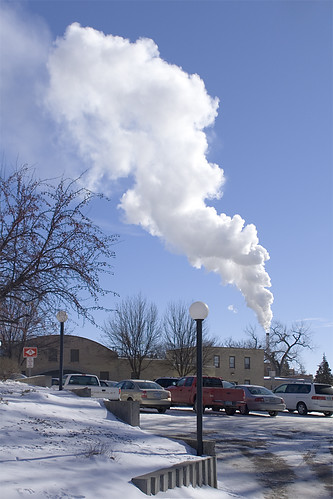
A ominous cloud of steam rises above the UND heating plant amid an ambient temperature of -19°F (-28°C) on one of the coldest days of the 2007-08 winter.
Labels: Brainerd Climate, Climate, Pictures, Weather
posted by Mitch Wahlsten at 7:22 PM
2 comments
![]()


